
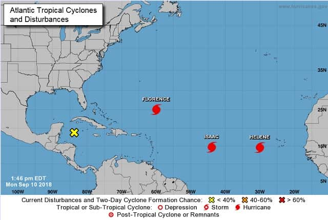
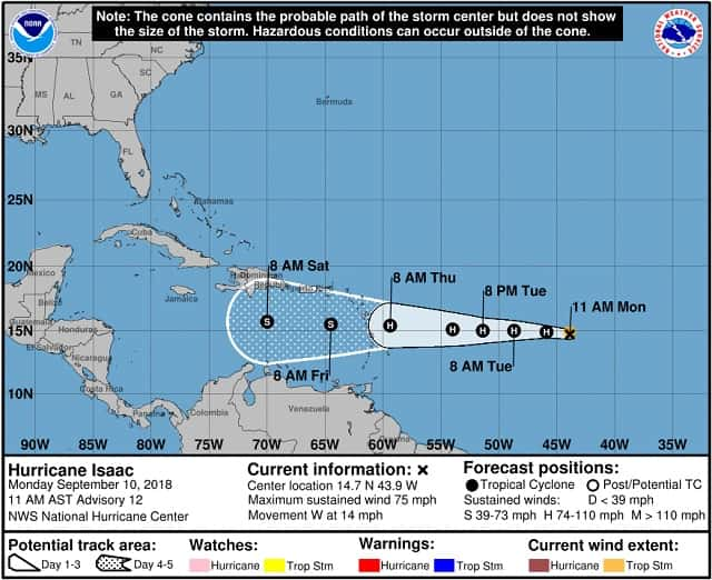
The tropics have suddenly become very active with three hurricanes and a disturbance churning out there. All but one could have an influence on our weather either directly or indirectly. Hurricane Helene is the longest distance away and is expected to turn north into the open Atlantic and probably not affect the U.S. A disturbance is just south of Cuba and may meander into the Gulf. What happens after that is still in question. Meanwhile, Hurricane Isaac is not reach the waters south of Haiti before Saturday. It is a small storm right now and is not expected to intensify much for a few days.
But all eyes are on Hurricane Florence. For those with interests in the Carolinas and even Virginia should be making preparations now ahead of an impact from a major hurricane. If you have loved ones living anywhere near the North and South Carolina Coasts, they should be encouraged to begin evacuating as soon as possible. Forecasters at the National Hurricane Center said in a special noon advisory, that Florence rapidly intensified to a potentially catastrophic Category 4 hurricane with maximum sustained winds near 130 mph.
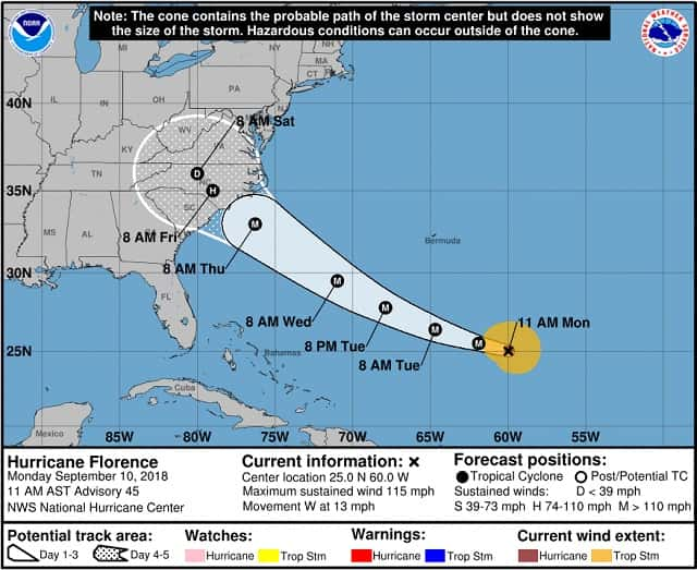
This storm will be the most powerful to hit the area in three decades with some winds gusting up to 150 mph. It may strengthen even more before it makes landfall. Up and down the coast, residents were rushing to ready emergency kits, map out escape routes and secure their homes in preparation for the onslaught of rain and wind the intensifying storm is expected to bring. All of the coast of South Carolina is under mandatory evacuation orders and evacuation is being encouraged for areas further inland. The hurricane is moving over progressively warmer waters over the next couple of days, with water temperatures peaking near 85F. Florence should continue to strengthen, and there is a possibility that it could reach Category 5 strength before making landfall. The National Hurricane Center says that a life-threatening storm surge is likely along portions of the coastlines of South Carolina, North Carolina, and Virginia, and a Storm Surge Watch will likely be issued for some of these areas by Tuesday morning. All interests from South Carolina into the mid-Atlantic region should ensure they have their hurricane plan in place and follow any advice given by local officials.
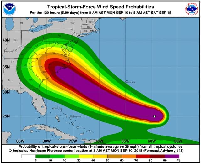
Life-threatening freshwater flooding is likely from a prolonged and exceptionally heavy rainfall event, which may extend inland over the Carolinas and Mid Atlantic for hundreds of miles as Florence is expected to slow down as it approaches the coast and moves inland. Some rainfall projections show that as much as 35 inches of rain could fall in some areas. Damaging hurricane-force winds are likely along portions of the coasts of South Carolina and North Carolina, and a Hurricane Watch will likely be issued by Tuesday morning. Damaging winds could also spread well inland into portions of the Carolinas and Virginia. The bottom line is that there is increasing confidence that Florence will be a large and extremely dangerous hurricane, regardless of its exact intensity and may pose a grave threat to lives and property. We will continue to monitor the situation and update accordingly.