
The calendar tells us that, officially, winter began Dec. 21st and ended March 20th but winter just seems to be hanging on. We get a few days warmth for April 11th through the 14th, but then we plunge back to below normal temperatures. There still isn’t a lot of foliage on the trees and it seems to be running a couple of weeks behind. That is to be expected considering as recently as the 7th, over 40% of the land in the U.S. was under 32 degrees, while nearly 50 percent of the population was below freezing!

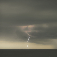
Statistics show that the first 8 days of this month so far are the coldest in 22 years across the region. We continue in an up and down temperature pattern where there are a few days of warmth followed by more cold. A multi-faceted storm will slam the central United States late this week around Friday the 13th with possible blizzard conditions to the north and severe thunderstorms to the south including the W. Ky. Area.
Warm, moist air from the Gulf of Mexico will be pulled northward across the nation’s midsection ahead of the storm. Along the line dividing the warmth with an advancing push of cooler air, thunderstorms will erupt late Friday into Saturday. Colder weather comes in behind this for Sunday and Monday with highs in the upper 40’s to around 50. There may be a quick rebound to warmer temperatures by mid-week next week. It is looking to me like we will continue seeing the cold shots outweighing the warm shots through the rest of the month. Each time the warmth comes in, there may be chances for severe storms to erupt. As we get deeper into spring, when we say temperatures will be below normal, it doesn’t mean they will be all that cold…just below normal which is in the 60’s right now.
So what is going on? Why is our spring so cold? There are several theories out there. But the one that has a lot of attention has to do with the sun. Reduced sunspot activity has been observed and indicates the sun is heading into a 50 year reduced solar activity similar to what happened in the mid-17th century.

Comparison to similar stars indicates the reduced activity will cause 0.25% less UV for 50 years. Modeling indicates that this will cause a few tenths of a degree of cooling globally. If that is what is happening, this will counteract global warming for 50 years. The cool-down would be the result of what scientists call a grand minimum, a periodic event during which the Sun’s magnetism diminishes, sunspots form infrequently, and less ultraviolet radiation makes it to the surface of the planet. Scientists believe that the event is triggered at irregular intervals by random fluctuations related to the Sun’s magnetic field.
Scientists have used reconstructions based on geological and historical data to attribute a cold period in Europe in the mid-17th Century to such an event, named the “Maunder Minimum.”
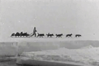
Temperatures were low enough to freeze the Thames River on a regular basis and freeze the Baltic Sea to such an extent that a Swedish army was able to invade Denmark in 1658 on foot by marching across the sea ice. A team of scientists led by research physicist Dan Lubin at Scripps Institution of Oceanography at the University of California San Diego has created for the first time an estimate of how much dimmer the Sun should be when the next minimum takes place. There is a well-known 11-year cycle in which the Sun’s ultraviolet radiation peaks and declines as a result of sunspot activity. During a grand minimum, Lubin estimates that ultraviolet radiation diminishes an additional seven percent beyond the lowest point of that cycle.
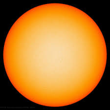 The reduced energy from the Sun sets into motion a sequence of events on Earth beginning with a thinning of the stratospheric ozone layer. That thinning, in turn, changes the temperature structure of the stratosphere, which then changes the dynamics of the lower atmosphere, especially wind and weather patterns. The cooling is not uniform. While areas of Europe chilled during the Maunder Minimum, other areas such as Alaska and southern Greenland warmed correspondingly. Lubin and other scientists predict a significant probability of a near-future grand minimum because the downward sunspot pattern in recent solar cycles resembles the run-ups to past grand minimum events. Other effects would be that longer, harsher winters may be in store for the portions of North America as the polar vortex continues to weaken and shifts, according to a new study.
 The polar vortex is a large pocket of frigid air that hovers above the Polar Regions, and is most prominent in the winter months. Researchers found that a loss of sea ice in the Arctic regions due to rising temperatures in the Barents-Kara seas, along with an increase in snow cover over Europe and Asia, has caused the polar vortex to weaken. The pocket of cold air has in turn shifted toward Eurasia. This movement could lead to colder and possibly extended winter seasons for portions of North America and Eurasia, according to the study. There is a lot of research still being conducted, and while some researchers may not find the latest study overly convincing, a mechanical connection between reduced solar activity, the lack of sea ice and the vortex shift seems to be playing a part in a shift to cooler conditions…at least temporarily. Time will tell.