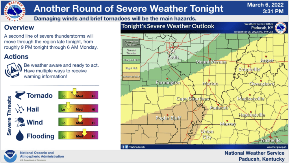
The National Weather Service says the risk of severe weather for Western Kentucky has increased for Sunday night, with severe storms possible through Monday morning.
The latest information from the National Weather Service indicates Western Kentucky has moved from a the marginal risk area to a slight risk Sunday evening, with that risk continuing until Monday morning.
The Hazardous Weather Outlook from the weather service indicates chances of severe thunderstorms may increase later this evening and overnight over much of the region as a surface low moves northeast out of the Southern Plains. Damaging wind gusts would be the primary thunderstorm hazard, though a brief tornado or two cannot be ruled out.
The National Weather Service has issued a Flash Flood Watch that continues until 9:00 Sunday evening for the counties of Christian, Trigg, Todd, Caldwell, Calloway, Graves, Hopkins, Lyon, Marshall, and Muhlenberg.
The first wave of showers and thunderstorms are expected to move across the quad-state region Sunday. The shower and thunderstorm activity is expected to continue throughout the day on Sunday over southern portions of west Kentucky, generating areas of excessive rainfall capable of producing one to three inches of rain over a short period of time. This will likely lead to isolated flash flooding especially into the early evening hours across the watch area. The excessive runoff may result in flooding of rivers, creeks, streams, and other low-lying and flood-prone locations.
The Weather Edge will continue to monitor the forecasts throughout the day and evening and provide coverage and updates when needed.