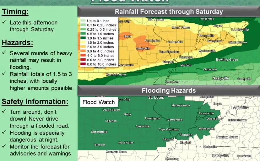

The National Weather Service in Paducah has issued a Flood Watch in effect from 3:00 Thursday afternoon through 6:00 Saturday evening for a portion of western Kentucky, including Caldwell, Crittenden, and Hopkins counties. The Flood Watch also includes the counties of Ballard, Henderson, Livingston, McCracken, McLean, Union, and Webster counties.
Meteorologists indicate a cold front will push through the area late Thursday afternoon and overnight bringing the first round of rain, which will be heavy at times, along with scattered thunderstorms. Another round or two of heavy rainfall is expected from Friday into Saturday as waves of energy stream along and north of the frontal boundary stalled to our south. Through Saturday, widespread rainfall totals of two to three inches are forecast, and locally higher amounts are possible.
Meteorologists also say thunderstorms late Thursday afternoon and overnight may bring rain heavy enough to cause localized flash flooding. They indicate repeat rounds of rain through Saturday will saturate soils and cause local creeks and streams to rise, resulting in more widespread flooding potential.
A Flood Watch means there is a potential for flooding based on current forecasts. You should monitor later forecasts and be alert for possible flood warnings. Those living in areas prone to flooding should be prepared to take action should flooding develop.