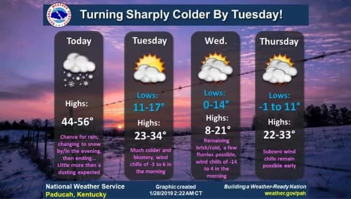
Western Kentuckians need to prepare for some of the coldest air to sweep across the region this year as a Polar Vortex dips into the south bringing life-threatening low temperatures through Thursday. In a special weather statement, the National Weather Service in Paducah says it will be bitterly cold overnight Monday through Wednesday night as a frigid arctic airmass spreads across the area. Tuesday evening, the true arctic front will move through, dropping wind chill temperatures into the zero to 10 below and continue into Wednesday night.
Meteorologists warn this cold snap will increase the likelihood of frostbite and hypothermia if precautions are not taken.
The National Weather Service is offering some safety tips to help you prepare for the extreme cold that includes:
– Check on elderly friends, family, and neighbors and those that live alone.
– Bring pets indoors or have a warm shelter out of the wind with plenty of unfrozen water and food.
– Run water a trickle to prevent frozen pipes.
– Do not use a stove or oven to heat your home.
– Place space heaters on a hard, level surface. Keep anything flammable at least 3 feet away.
– Never leave alternate heat sources unattended.
– Properly ventilate alternate heat sources.
– Know the signs of carbon monoxide poisoning.
– Recognize symptoms of hypothermia, which includes confusion, shivering, difficulty speaking, sleepiness, and stiff muscles. Also, you need to know how to treat hypothermia.
– Have a winter survival kit in your vehicle, and keep your vehicle’s gas tank at least half filled.
In addition, dressing in multiple layers of clothing, as well as wearing a hat/toboggan, gloves, and waterproof boots can also help fight the extreme cold.
Meteorologists indicate the area will quickly break out of the cold, with much warmer conditions returning by the end
of the week.