As I start this winter outlook, many of you know that I have said all along that we will only have two seasons this year…Winter and Summer. We began the year with winter temperatures hanging on into April, then we had about two weeks of spring before going into summer the last couple of weeks of April. The summer was a long, hot one and didn’t end until the first part of October. This kept our leaves from changing color until the last week of October. I also don’t recall ever seeing where a Pacific hurricane came into Mexico and ended up affecting our weather, much less two of them. The first was Sergio which dumped heavy rains on normally dry Arizona, and the second was Willa which slammed into Mexico as a category five then crossed into the Gulf of Mexico. This must have happened sometime in the past but I don’t remember ever seeing it in my lifetime.
 Then you have an amazing amount of early season snow and cold up in Canada and that cold is likely going to play a part in our weather going forward. So everyone has been asking me what type of winter I think we will have, especially considering the unusual overall patterns we have been seeing. I wish the answer was simple but it isn’t. There are many variables this year that aren’t normally in play. So I will start the process of explaining the process of trying to figure it all out and come up with a good idea on what we can expect.
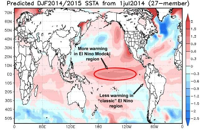
 The models are mostly predicting a weak El Niño for this upcoming winter. El Niño is the appearance of unusually warm water in the Pacific Ocean, according to the National Oceanic and Atmospheric Administration. “The presence of El Niño can significantly influence weather patterns, ocean conditions, and marine fisheries across large portions of the globe for an extended period of time,” NOAA explains on its website. El Niño is thought to favor warmer than normal temperatures for the Northwestern US, Alaska and Western Canada with colder than normal temperatures for the Southeastern US. The models are also predicting that the focus of the El Nino in the equatorial Pacific will be in the Central and not Eastern Pacific like we normally see, and also referred to it as an El Niño Modoki. Basically this means it is further west than a usual El Nino and will have a significant influence on the winter season. This would favor a colder eastern U.S as well as a southern storm track. But there is more at play than just that. Another factor is the amount of snow cover in northern areas, rapidly advancing and an indication for a weak polar vortex (PV). A weak Polar Vortex means it may be able to break free of the prison of wind currents and drop southward. The advance of snow cover south of 60°N has been slow so far. But that can change quickly and a slow start actually makes it easier for a big number by the end of the month.
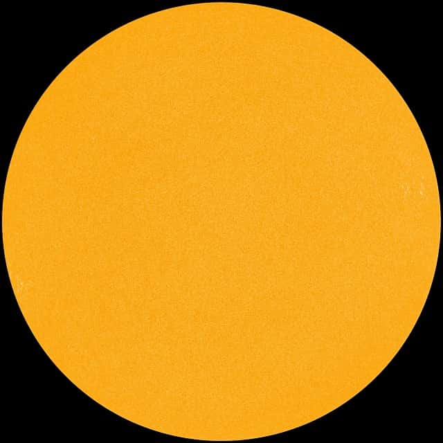 Another big factor is the sun. The sun is entering one of the deepest Solar Minimum of the Space Age. Sunspots have been absent for most of 2018, and the sun’s ultraviolet output has sharply dropped. New research shows that Earth’s upper atmosphere is responding. “We see a cooling trend,” says Martin Mlynczak of NASA’s Langley Research Center. “High above Earth’s surface, near the edge of space, our atmosphere is losing heat energy. If current trends continue, it could soon set a Space Age record for cold.” This affects us because Earth’s climate gets cooler when there are fewer solar storms. The extreme example happened between 1645 and 1715 when the normal 11-year sunspot cycle vanished. This period, called the Maunder Minimum, was accompanied by bitterly cold winters in the American colonies. Fishing settlements in Iceland and Greenland were abandoned. Icebergs were seen near the English Channel. The canals of Venice froze. It was a time of great hardship.
 While the last couple of winters have not been very harsh, a very active winter is predicted for the Southeast, Tennessee Valley and Gulf Coast this season. What’s left of October is looking cool but not overly cold. By Halloween, colder air seems to be getting more and more into our pattern. But not before a big storm system arrives in our region bringing heavy rains…maybe some severe storms as we go into the first of November. November begins with unsettled conditions and below normal temperatures with highs in the upper 50’s. The storms will keep rolling along over the eastern part of the United States well into November. On average, most areas can expect a significant rain event every two to three days, which is likely to result in above-average rainfall. There is the possibility for a sizable storm to develop over the South Central states or over the Gulf of Mexico around November 3rd or 4th. Models seem to indicate that the storm could pack a punch in terms of heavy rain and strong winds.
 November is looking a little less up and down in temperatures. Though models send a surge of cold south in the first several days, it looks to moderate as winds begin to blow from the Pacific across the continent. A mild month looks likely as the polar vortex is strengthening over the north which should result in more zonal, and mild air moving in. The first half of November looks pleasant as far as temperatures go with no real cold shots and no real warm shots of air either. Warm spells can, and often do, happen in November and sometimes we experience Indian Summer. Even severe weather. The colder air should arrive more in the late month. I expect the intrusions of cold air to start arriving between the 20th and Thanksgiving with rain possibly changing to some light snow. It shouldn’t be a big deal though just yet. Highs will be in the 40’s with lows well below freezing. Another storm right after Thanksgiving, around the 27th, threatens to bring a chance of a little frozen precipitation.
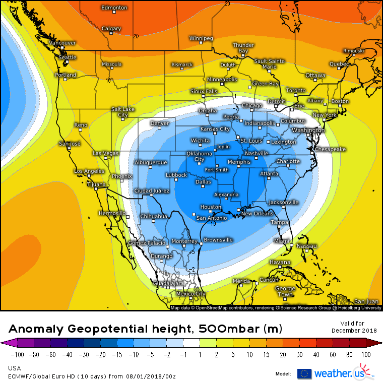
Then December arrives with a threat of a wintry mix the first few days of the month as Arctic air invades the region. This will signal the start of a series of cold air assaults on our region as a blocking pattern sets up over Greenland and forces colder air into the eastern U.S. In regards to the US winter there looks to be a suppressed storm track along the Eastern Seaboard. A positive PNA blocking pattern, should yield an overall cold winter in the Eastern US. Another wintry mix arrives by the 7th. By the 11th of December, high temperatures will struggle to get above the mid 30’s with snow flurries off and on through the 14th. As far as a white Christmas, there is a storm indicated at that time in the long range models but temperatures seem just a bit too warm. Still it is close so I would give our chances right now at 50 – 50. While December will have a few storms that may contain snow, they are expected to become more frequent in January and February.
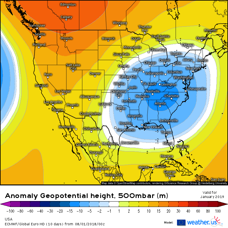
January and February will much higher chances for snow and ice threats, with multiple storms coming at our region. It is at this time that there is a possibility of the Polar Vortex getting involved with our weather. As cold shots become more frequent from mid- to late winter, even the central and western Gulf Coast will be susceptible to frost and freezes. Overall, if everything stays on track, the setup looks like it will be a pretty harsh winter around our region that lasts well into March. Just bear in mind that these are long range trends and nothing in this outlook is in concrete. But it is an idea of what I believe we will see this year. Snow lovers should be very happy with this.


