
Florence’s satellite signature remains very impressive even though the eye is now located just inland over southeastern North Carolina near Cape Fear. However, land interaction has taken its toll on the inner-core circulation, and the previously well-defined eye in radar imagery has shrunk and become filled with rain echoes. At 200 PM EDT (1800 UTC), the center of Hurricane Florence was located near latitude 34.0 North, longitude 78.4 West. Florence is now moving toward the west near 5 mph (7 km/h). A slow westward to west-southwestward motion is expected today through Saturday. On the forecast track, the center of Florence will move farther inland across extreme southeastern North Carolina today, and across extreme eastern South Carolina tonight and Saturday. Florence will then move generally northward across the western Carolinas and the central Appalachian Mountains early next week.
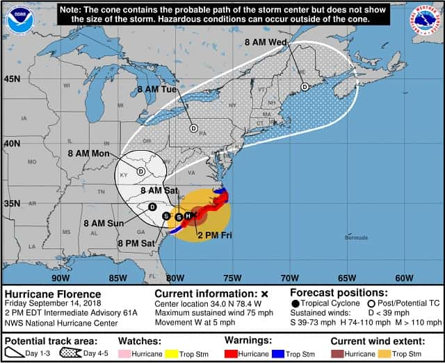
Maximum sustained winds have decreased to near 75 mph (120 km/h) with higher gusts, mainly over water. Gradual weakening is forecast later today and tonight. Significant weakening is expected over the weekend and into early next week while Florence moves farther inland. Hurricane-force winds extend outward up to 35 miles (55 km) from the center and tropical-storm-force winds extend outward up to 170 miles (280 km). A wind gust to 66 mph (106 km/h) was recently reported at the National Ocean Service station in Wrightsville Beach, and a 75 mph (121 km/h) was recently reported at a Weatherflow site just north of Cape Fear at Federal Point. Farther inland across North Carolina, a wind gust of 60 mph (96 km/h) was recently at the Fayetteville airport. Another Air Force Hurricane Hunter aircraft will be sampling the portion of Florence’s circulation over water during the next few hours. As a shortwave trough currently located over the eastern Great Lakes to Maryland moves eastward away from the region over the next 2 days, the ridge will begin to build back in and shift eastward, allowing Florence or its remnants to gradually turn northward over the weekend, and then move northeastward into the mid-latitude westerlies as an extratropical low. Wind data from the earlier aircraft mission, along with Doppler radar velocity data and surface observations, indicate that Florence has weakened. Additional slow weakening is expected today as the center of Florence moves farther inland, with more rapid weakening forecast over the weekend as Florence moves westward across South Carolina. The new NHC intensity forecast is a little lower than the previous advisory, and closely follows the trend of Decay SHIPS model.
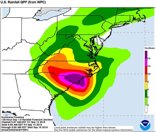
Although coastal storm surge flooding will gradually subside later today, it cannot be emphasized enough that another serious hazard associated with slow-moving Florence is and will be extremely heavy rainfall. More than 14 inches of rain has already fallen in many areas across southeastern North Carolina, and more rain is still to come, which will cause disastrous flooding that will spread inland through the weekend. A life-threatening storm surge is already occurring along portions of the North Carolina coast and will continue through today and tonight. This surge is also likely along portions of the South Carolina coast. The greatest storm surge inundation is expected between Cape Fear and Cape Hatteras, including the Neuse and Pamlico Rivers and western Pamlico Sound. Life-threatening, catastrophic flash flooding and prolonged significant river flooding are likely over portions of the Carolinas and the southern and central Appalachians through early next week, as Florence is expected to slow down while it moves inland. Damaging hurricane-force winds are occurring along portions of the North Carolina coast and are expected to spread to portions of the South Carolina coast later today. Strong winds could also spread inland into portions of the Carolinas over the next couple of days. Large swells affecting Bermuda, portions of the U.S. East Coast, and the northwestern and central Bahamas will continue this week, resulting in life-threatening surf and rip currents.