There is lots of speculation on what our summer will look like considering the cooler than normal temperatures the first 4 months of 2018. More recently, we have been sweltering in hazy, hot, and humid conditions that have many wondering what happened to our spring. The heat that surged into the region late this past week and continued through the weekend may have been hard to take for some residents, given the unseasonably cool conditions that persisted for much of April.

While our area hasn’t officially hit the 90 degree mark just yet, the heat index has made it feel like the lower to mid-90’s in some spots. Not only that, a tropical low in the Gulf of Mexico is slowly moving north towards Kentucky. Moisture from that storm from the tropics and a slow-moving front to the north will converge and lead to a few days of possibly off and on heavy rainfall. A lot will depend on the track of that low and the interaction with the frontal boundary the next few days. This type of tropical influence is a little unusual for early to mid-May. There doesn’t appear to be any cool downs other than briefly due to rain and clouds at times.

The thing is, you get the impression that this setup will continue into the first couple of weeks of June. Some of the long range models indicate that much of Kentucky could see as much as 10 or 11 inches of rain over the next six weeks. That comes out to be near two inches of rain per week. The other issue is that the Bermuda High is already influencing our weather. The Bermuda High is a high pressure area that is usually centered in the vicinity of Bermuda during the spring and summer.
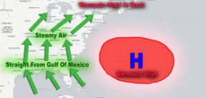
This high pressure area is responsible for the prolonged heat waves in the Eastern part of the country. While we are not in a heat wave, the circulation around the high is helping feed tropical moisture and heat into the region and helping provide fuel for thunderstorms. As long as it remains in its current position, we can expect more of the same. At some point, it will more than likely expand westward and therefore drive the showers and storms to the west of our region. Then we will experience true summer with hazy, hot, and humid days that are only good for dogs lying in the shade.

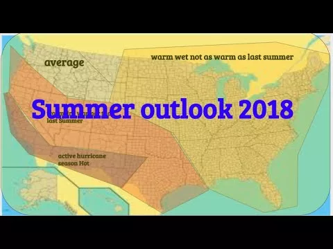
I expect this to happen sometime around the last week or two of June leading into July. Summer officially begins Thursday, June 21, 2018, at 6:07 a.m. EDT. This is the date of the Summer Solstice, the longest day of the year in terms of daylight. For many, it’s one of the most anticipated seasons of the year… (Not me). Overall, I expect a hot summer for most of the country, with above-normal temperatures dominating the months of June, July, and August. However, it does look like this summer will be hotter than last summer across the Southeast, and even the Great Lakes region should experience more hot weather than they did last year. One last thing that worries me about the summer will be the worsening drought conditions across western and central parts of the United States, with a significant impact on agriculture and wildfires.

Severe to exceptional drought is currently stretching from Arizona and Utah to Kansas, Oklahoma and the western half of Texas. Let’s hope we can get some rainfall into those areas before the Bermuda High takes over. A hot summer, especially early on, is on the way. There are signs that much of the middle and western areas of the country will see the hottest temperatures, especially in July. Better have those air conditioners ready! July is looking quite hot as does the first half of August. But it also looks like an early ending of summer may be possible going into the second half of August. Current outlooks are trending toward a cooler September when Autumn will make it much more comfortable to enjoy the outdoors. Bear in mind that this is an indication of the trends in our weather pattern but nothing is in concrete. But I did want to share these trends with you.