After inundating Texas and Louisiana for days, Harvey will race across the Ohio Valley with rain and wind. Winds of 20 to 30 mph with gusts to 40 mph will be possible as Harvey shows it is still a powerful storm. While Harvey is not expected to bring widespread flooding, or flooding anywhere close to the disaster in Texas, enough rain is likely to fall to bring urban and isolated flash flooding to some areas.
Luckily, the system has sped up some. This increase in forward speed will prevent Harvey from repeating the feet of rain  which has fallen near the Gulf coast. On occasion, old tropical systems can pulse and cause much heavier rain to erupt in a small area well inland. That is something we will have to watch out for. Thanks to the dryness we have had over the past couple of months, western Kentucky can probably take up to 5 inches of rain before any flooding is too noticeable. It all depends on how fast the rain falls at any given time. Our area can expect 5 to 6 inches so it looks like we may be in good shape overall.
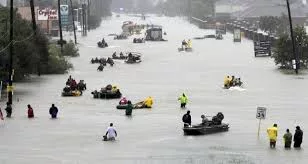
There is good news, in that it will not rain the entire holiday weekend. Houston has reported sunshine today and the rains there seem to have ceased. Now recovery can begin in earnest. Many businesses, churches, and volunteers from all over are gathering relief supplies and ready to head for Texas soon. The studios of WKDZ/WHVO are one of those collection points and the supplies collected there will depart on Sept. 1st.  This will end up being the worst natural disaster in American history. The economy’s impact, by the time its total destruction is completed, will approach $160 billion, which is similar to the combined effect of both Hurricanes Katrina and Sandy.
This represents a negative impact on the economy of 8/10 of one percent of the gross national product or GDP. The GDP is $19 trillion currently. Business leaders and the Federal Reserve, major banks, insurance companies, etc. should begin to factor in the negative impact this catastrophe will have on business, corporate earnings and employment. The disaster is just beginning in certain areas. Parts of Houston, the United States’ fourth largest city, will be uninhabitable for weeks and possibly months due to water damage, mold, disease-ridden water and all that will follow this, what has  been called a 1,000-year flood.
While the Gulf Coast continues to deal with the devastating impacts of Harvey, emergency managers in the United States have another tropical threat to monitor by the name of Irma. This new system is forecast to strengthen to a hurricane and may approach the northeastern Caribbean islands during the middle of next week. Conditions are favorable for tropical development throughout the central Atlantic, heightening the threat of significant strengthening as this system approaches the U.S. There is the potential for it to ramp up to a powerful hurricane in the c oming days. Steering winds may bring it close to the U.S. before the middle of the month. Irma will take about a week for the system to make its trek westward across the Atlantic Ocean.
Possibilities range from a landfall on the Leeward Islands in the northeastern Caribbean to the Carolinas and the island nation of Bermuda. Residents who live along the East Coast or have interests in the Caribbean Sea should take time to review emergency procedures and make sure they are prepared for extreme tropical conditions over the next couple of weeks. If recent events have taught us anything, it is the importance of coming together and being prepared for any disaster. In the midst of the disaster in Texas, there is no distinction between colors, or whose lives matter the most. The protests across the country on what statues should remain or not, have ceased. Many people are realizing that we are all Americans, all lives matter and we are coming together during this difficult time. I am sad for what happened but proud of the outpouring of love and caring shown by my fellow countrymen. Feel free to comment and please hit the like button at the bottom.