A few things have changed since I last posted an extended range outlook. There are a couple of things that I know you will be interested in, especially with the holidays coming up.
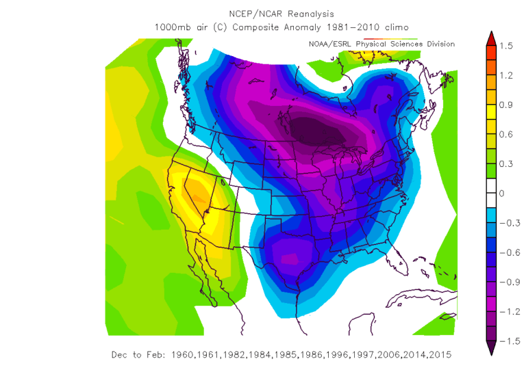
I am sick of the really warm temperatures when we should be cool. The reason we have seen this heat is due to the La Nina in the Pacific Ocean. I told you in my last outlook that it would play a role in what type of weather we get. In a typical La Nina, we get warmer and drier weather overall. We have certainly had that so far. A weak La Nina is still present but there are signs of change.
I think the La Nina will slowly weaken as the weeks go by which will lead to a cooler pattern. But when I say cooler, I’m referring to temperatures getting back to where they should be for this time of year. Colder, below normal temperatures is a different story. One of the problems is the abnormally dry to almost drought like conditions over the region. You get a kind of “high pressure" that forms over widespread dry and drought areas. It is hard to break those patterns once they set up, but not impossible. Significant cold attacks are still expected. As the La Nina weakens and waffles back down in strength, I expect cold air intrusions will start to get further south.
So here is what things look like to me right now. I have been watching a storm around the 11th or 12th of November that may help usher in colder air. If everything continues on track, I look for a cold wave later in November, aroun d Thanksgiving or a day or two afterwards. Another system around December 1st through the 3rd could bring rain and a few snow showers as lows fall below freezing. During December, especially from mid-month on until Christmas, I suspect we will find our region in the zone for a risk of warm air advection winter events. In other words, a situation where warm air rides over the top of colder air at the surface. It also means that we will find ourselves more on the fence of the dreaded rain/snow/ice line that divides our area many times in winter. It could mean that larger snow events are possible.
But the bigger worry is the greater threat of an ice storm than in previous years. Once we get into Christmas week, a system may bring colder air and a chance for snow during that time. The chances for a white Christmas may be a tad better than in the last few years. This far out, it is hard to pinpoint exactly where the snow will set up, if at all. There are signs that the polar vortex may set up near Hudson’s Bay after Christmas and may bring us a significant wintry event sometime between Christmas and New Year’s Day. This is near the same location the Polar Vortex set up a couple of years ago when our region received the cold temperatures and deep snows.
I suspect the Polar Vortex will influence our weather through much of January and at least into early February. There may be the usual January thaw for about a week like we normally see around mid-January. But there seems to be the possibility for several snow events during the month. Again…it is hard to get specific with dates this far out. Overall, February looks cold and snowy as well. But as we get into the latter part of the month, we may start to see some warm air intrusions. This type of pattern could lead to off and on severe storm threats followed by cold returning once again.
March promises to be an up and down month as far as cold and snow, especially early on. Overall, spring weather won’t be around much before April. So, if you are a snow lover, this may be your year. Time will tell. Feel free to leave comments and be sure to hit the “Like” button at the bottom of this post.
I
think the La Nina will slowly weaken as the weeks go by which will lead to a cooler pattern. But when I say cooler, I’m referring to temperatures getting back to where they should be for this time of year. Colder, below normal temperatures is a different story. One of the problems is the abnormally dry to almost drought like conditions over the region. You get a kind of “high pressure" that forms over widespread dry and drought areas. It is hard to break those patterns once they set up, but not impossible. Significant cold attacks are still expected. As the La Nina weakens and waffles back down in strength, I expect cold air intrusions will start to get further south.So here is what things look like to me right now. I have been watching a storm around the 11th or 12th of November that may help usher in colder air. If everything continues on track, I look for a cold wave later in November, aroun
d Thanksgiving or a day or two afterwards. Another system around December 1st through the 3rd could bring rain and a few snow showers as lows fall below freezing. During December, especially from mid-month on until Christmas, I suspect we will find our region in the zone for a risk of warm air advection winter events. In other words, a situation where warm air rides over the top of colder air at the surface. It also means that we will find ourselves more on the fence of the dreaded rain/snow/ice line that divides our area many times in winter. It could mean that larger snow events are possible.But the bigger worry is the greater threat of an ice storm than in previous years. Once we get into Christmas week, a system may bring colder air and a chance for snow during that time. The chances for a white Christmas may be a tad better than in the last few years. This far out, it is hard to pinpoint exactly where the snow will set up, if at all. There are signs that the polar vortex may set up near Hudson’s Bay after Christmas and may
bring us a significant wintry event sometime between Christmas and New Year’s Day. This is near the same location the Polar Vortex set up a couple of years ago when our region received the cold temperatures and deep snows. I suspect the Polar Vortex will influence our weather through much of January and at least into early February. There may be the usual January thaw for about a week like we normally see around mid-January. But there seems to be the possibility for several snow events during the month. Again…it is hard to get specific with dates this far out. Overall, February looks cold and snowy as well. But as we get into the latter part of the month, we may start to see some warm air intrusions. This type of pattern could lead to off and on severe storm threats followed by cold returning once again.
March promises to be an up and down month as far as cold and snow, especially early on. Overall, spring weather won’t be around much before April. So, if you are a snow lover, this may be your year. Time will tell. Feel free to leave comments and be sure to hit the “Like” button at the bottom of this post.